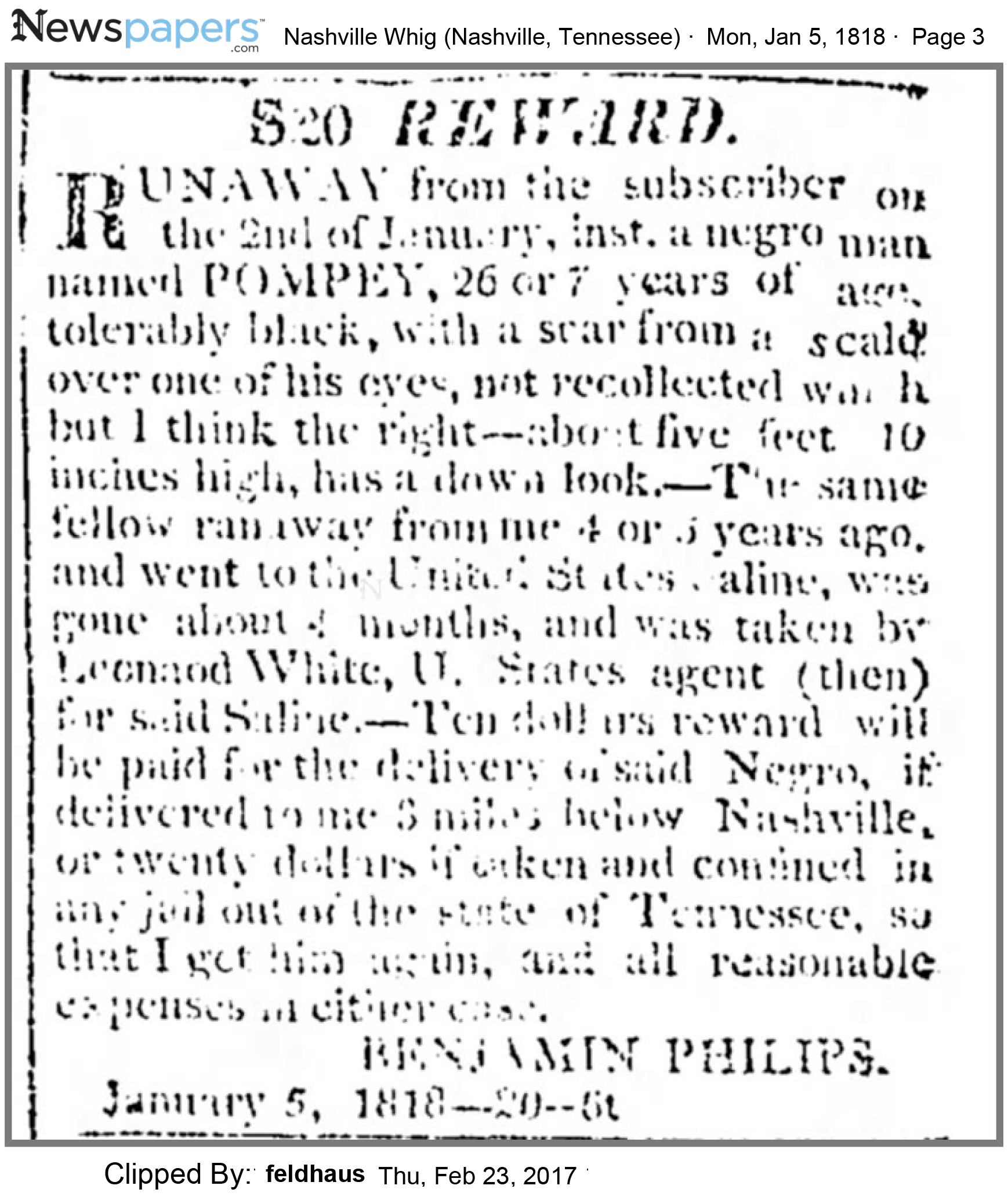
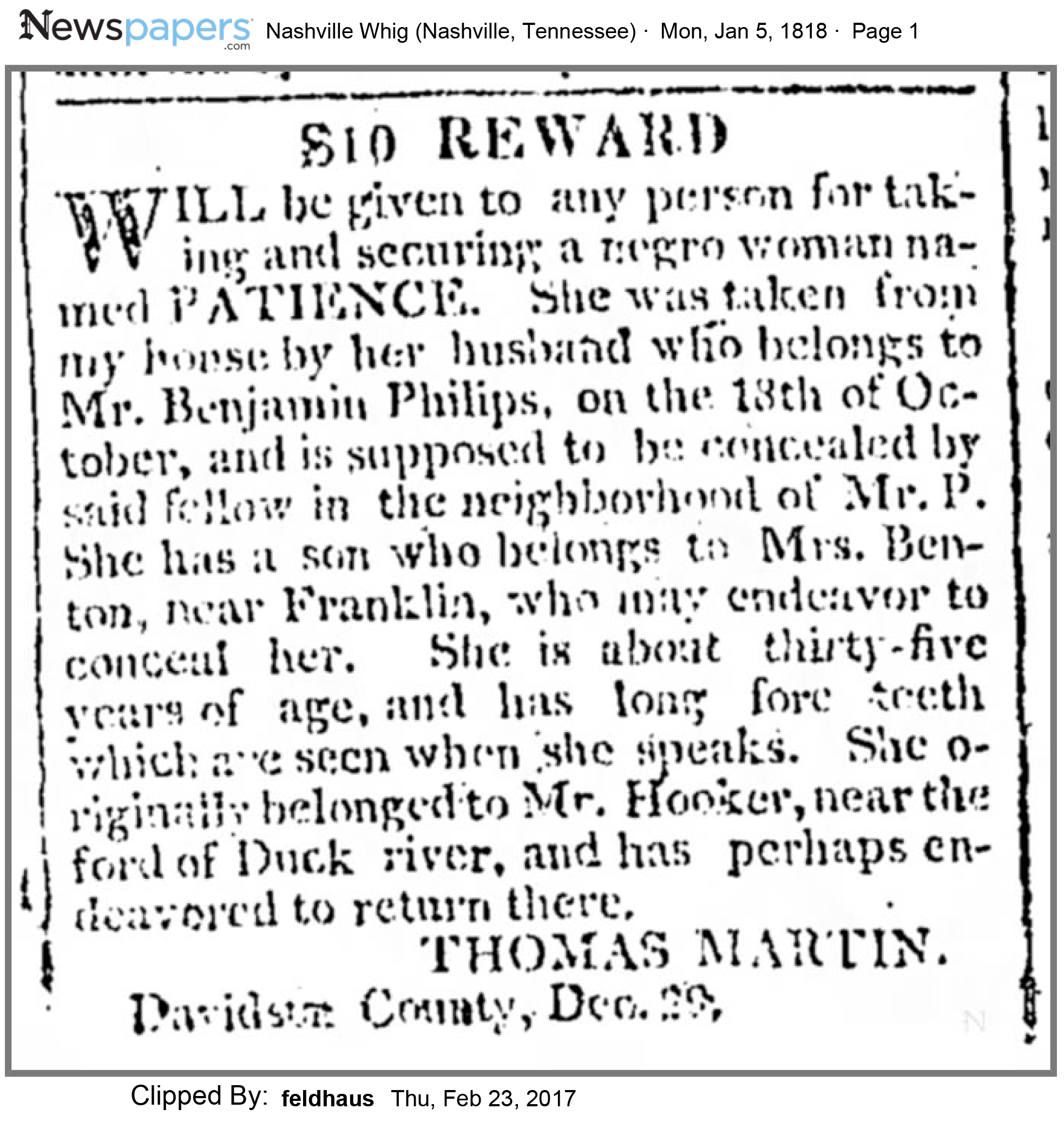
|
|
In 1790 Benjamin Philips was still in NC on
Fishing
Creek outside of Tarboro in 1790 and living near his brother Joseph who came to
Nashville in 1791. Both were wealthy
farmers in NC and owned considerable land which they sold when they moved to
Nashville were they purchased land.
BENJAMIN, 700 A tract of land, granted me by a Deed bearing date 15th day
Oct. 1761, lease plantation, mill and appurtenances which I purchased of JAMES
GRAY on the S side of Tar River where my son BENJAMIN now lives, all stock and
cattle on said plantation; and negro girl.
August Court 1789 - Friday August 7, 1789 May 1795: Patrolers for the ensuing year: Capt. Philips District - Cullen
Andrews, Jno Murphree, Benjamin Philips, William Horn.
The book
Southside Virginia Families, Volume 2, By
John Bennett Boddie, Published 1956, Pages 350-356 has a section on the Philips in which it states "Benjamin Philips settled near
Nashville TN and is untraced". The book goes on the say: "Exum Philips,
died November 1802. His will probated Edgecombe W. B. "D", p. 152 mentions daughter Polly, sons Mathew, James, Joseph, and
Thomas Philips and directed that his brothers Joseph and Benjamin Philips, then in Tennessee, settle his sons Mathew and James
in that state. Joseph Philips, son of Exum Philips, m. Anne Taylor and left a will." This would subtantiate that Benjamin
was in TN in 1802 with his brother Joseph who had relocated to six miles north of Nashville in 1791. Benjamin Philips came to Tennessee with his widowed sister
Sarah Philips in 1795 according to her obituary as reported on her web page on this site.
Benjamin is shown in the
Davidson County Deed Index with the following purchases of land:
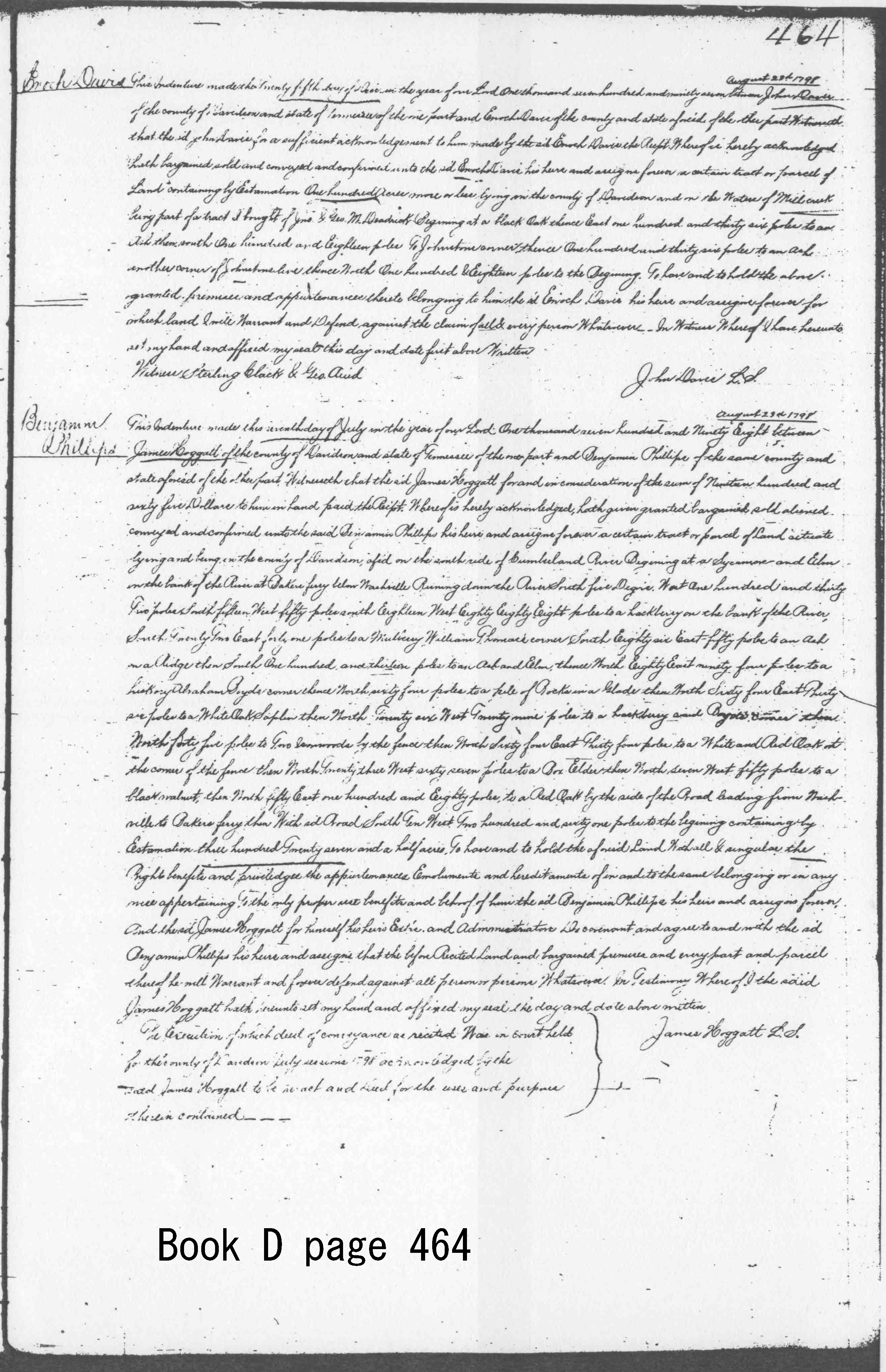
Bob
Pierce copied the deed from James Hoggatt to Benjamin Philips dated 23 August
1798 for 327 ½ acres “lying and being in
the county of Davidson, aforesaid on the south side of Cumberland River
Beginning at a Sycamore on the bank of the River at Bakers ferry below Nashville
Running down the River South five Degrees West one hundred and thirty two poles,
south fifteen West fifty poles, south Eighteen West Eighty Eighty Eight poles
to a hackberry on the bank of the River, South Twenty Two East forty one poles to a Mulberry William Thomas corner, South
Eighty six East-fifty poles to an Ash on a Ridge then South One Hundred and thirteen poles to an Ash and
Elm, thence North Eighty East ninety four poles to a hickory Abraham Boyds corner
thence North
sixty four poles to a pile of Rocks in a Glade then North Sixty four East
Thirty six poles to a White Oak Saplin then North twenty six West Twenty nine
poles to a hackberry said Boyds corner then North forty five poles to Two
Ironwoods by the fence then North Twenty three West sixty seven poles to a Box Elder then North Seven West fifty poles to
a black walnut, then North Fifty East one hundred and Eighty poles, to a Red Oak by the side of the Road leading from Nashville
to Bakers ferry then With said Road
South Ten West, Two hundred and sixty one poles to the beginning containing by
Estimation three hundred Twenty seven and
a half acres. To have and to
hold…….”
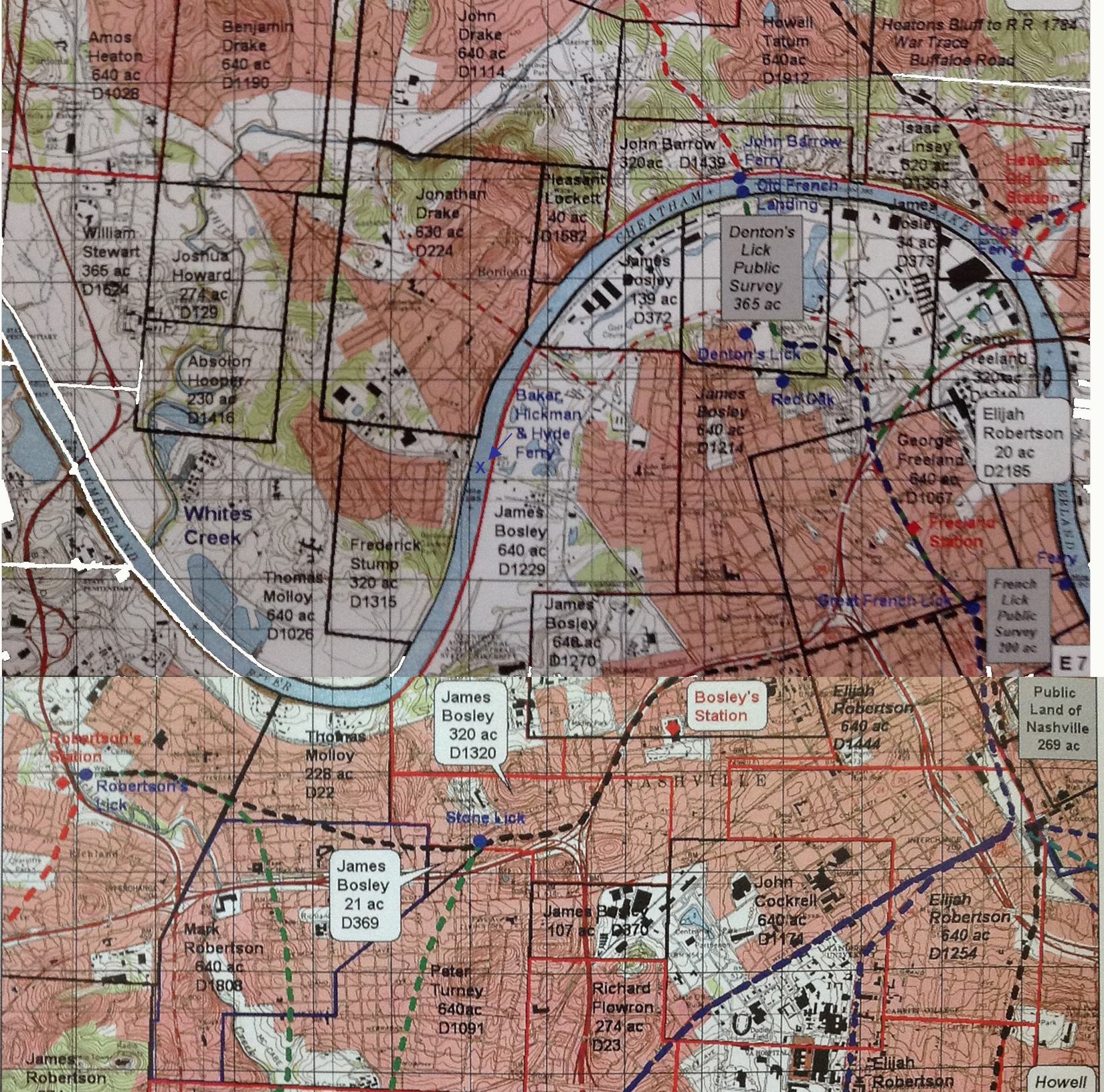
“Bakers Ferry” is the
only thing in this deed that gives the location of the 327 ½ acres. I found the following information about
Bakers Ferry.
“Davidson County, TN Court Minutes 1792-1799
by Carol Wells
From the above, it
appears that Hickman operated a ferry at the mouth of Sulphur Creek which creek
still bears that Sulphur Creek name and
is located about half way to Ashland City where the creek runs into the
Cumberland River.
The road running from
Ashland City is named Old Hydes Ferry Pike and blends with the Ashland City Hwy
and runs to near the Cumberland River where it diverges with the name Hydes
Ferry Rd. and ends up across the Cumberland River from the end of Buchanan
Street where Hydes Ferry was located, thus the name “Hydes Ferry Pike”.
The following
reference further describes the location of Baker’s Ferry which was
awarded to Joshua Baker near his house.
Later it was operated by Hyde and Hickman families.
Hidden History of
Nashville
By George R. Zepp
This
early branch of
Davidson County's ferry system didn't start with a member of the Hyde family,
but Hydes later operated it for decades, so it took their name. It began in
1794, just west of the western end of the present Buchanan Street, in the
Bordeaux area of north Nashville. The county's northwest section depended on
it. A
July I5 grant that
year by the Territory of the United States of America South of the Ohio River
awarded the Cumberland River crossing to Joshua Baker near his house, Davidson
County court minutes show. Later, it was
operated by Thomas Hickman, once a county sheriff, and afterward by Henry Hyde. Hyde
arrived in
Nashville in1800 but died in 1812. Some
of his six sons and their offsprings helped keep the ferry crossing in the
family.
The Hyde's Ferry
Turnpike Company was chartered January 25, 1848, for the purpose of
constructing a turnpike from Nashville to Sycamore Mills. The first meeting of
the company was held at Zion's Meeting-house November 1, 1848, Thomas Harding,
David T. McGavock, Richard Hyde, R. A. Barnes, Lewis Williams, William Drake,
Edmund Hyde, 0. A. Simpkins, Dennis Dozier, and Thomas W. Sehon being the
commissioners to receive subscriptions to the stock. F. R. Rains, David T.
McGavock, J. E. Manlove, Dennis Dozier, 0. A. Simpkins, Thomas Harding, and
Robert A. Barnes were the first Directors, of whom
John E. Manlove
was President, and Robert A. Barnes Secretary. The capital stock was fixed at
$30,000, and was afterward increased to $50,000. By 1853 the road was
built to the bluff below Hickman’s Ferry, and year by year additions were made
to its length until the completed road reached Marrowbone, sixteen miles from
Nashville. The war cut off further construction, and a resolution was adopted
by the Board of Directors deciding to go no farther. After the war, in 1870,
work was resumed, but not until 1878 was the whole road opened up, and it was
not completed until 1884. It is twenty-four miles long, and extends from Nashville
to Lyceum Mills, and cost $5o,000. The present Board consists of B. G. Hampton,
W. P. Harding, W. R. Hyde, W. M. Pegram, G. Stritch, and E. C. Lewis. The officers
are: B. G. Hampton, President;
and E. C. Lewis, Secretary and Treasurer. The above
descriptions identify the location
of Baker’s Ferry where the
railroad trestle is now located at the end of Buchanan Street in Nashville. I found on the web “Descendants
of Mathew (III) Talbot” but no
indication where he lived: Matthew(III) Talbot b: 1756 in Bedford Co., VA d: 1804 in
Davidson Co., TN All of the
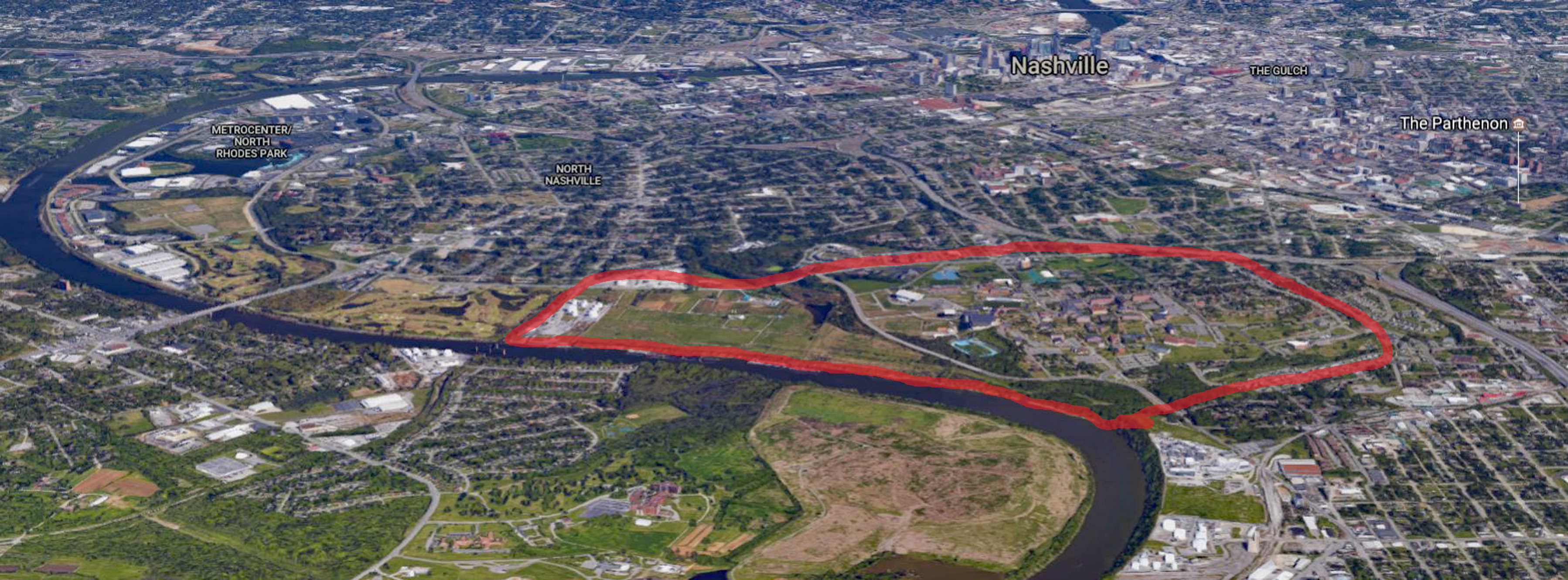
above information puts the 327.5 acres that Benjamin Philips bought from James Hoggatt
on 23 August 1798 at the end of Buchanan Street adjoining the Cumberland River
and lying on the south of the current location of the Ted Rhodes golf course
and the railroad bridge now located where Baker’s Ferry once operated. See the red X below.
I should
mention that Dr. James W. Hoggatt who sold this land to Benjamin Philips was a
wealthy individual who built the Clover Bottom plantation and mansion in
Donaldson. The picture below shows what
it looks like in 23 May 2012.
Bob Pierce
also copied the deed transferring 100 acres of land to Benjamin Philips in 1801
from William Lytle. It’s very hard to
read, so I didn’t try to transcribe it here, but I was able to find out who
William Lytle is. Turns out, he's the founder of Murfreesboro TN. William LYTLE Birth 15 FEB 1775
in Lancaster County,
Pennsylvania Death 4 SEP 1829
in Murfeesboro,
Rutherford, Tennessee I found the following
at >http://www.tngenweb.org/rutherford/lytlefam.htm where there is an interesting story about his family: Captain Lytle is
said to have settled his
land and was the only family in the vicinity at the time. When there was
an Indian attack, he moved back to Davidson County for two years before attempting
to settle again. The second attempt was successful. Rutherford
County was formed from Davidson County in 1803, and when enough settlers had
come into the area, a decision was made to lay off a town. After a
lengthy debate as to the location, William Lytle offered to donate 60 acres for
the site. It was named for Hardy Murfree, the officer who had led the
charge of the Patriots when they had stormed and seized Stony Point on the
Hudson, July 1770. William Lytle’s house
was pictured in the book “History of
Homes and Gardens of Tennessee (1936) by the Garden Study Club of Nashville”. It
is possible that Captain Lytle sold his land in Nashville to Benjamin Philips
when he decided to return to Rutherford County.
However the deed is so hard to read that establishing a location and
size of the property described in the deed is almost impossible. Also, the landmarks
in the deed don’t locate
the property very well. However, the
fact that Benjamin later purchased 31 ¾ acres from William Lytle Jr. in 1815
that lay on Stones Lick Branch makes one think that the 100 acres also was in
this area.
Deed from Dempsey and Elizabeth
Fields to Benjamin Philips 11 Oct 1803 Davidson County Deed Book F,
Page 84 23 acres more or less Benjamin Phillips This indenture made this eleventh
day of October in the year
of our Lord one thousand and eight hundred and three between Dempsey Fields and
Elizabeth Fields his reputed wife formerly the widow Smith of the one part and
Benjamin Phillips of the other part all of Davidson County and state of
Tennessee witness that the said Dempsey and Elizabeth for and in consideration
of the sum of one hundred and twenty dollars to him in hand paid the receipt
whereof is hereby acknowledged and him the said Benjamin forever therefrom
exonerated and acquitted hath bargained and sold by these presents bargain sell
enfee off and convey to the said Benjamin his heirs and assigns forever a
certain tract or parcel of land lying and being in the county of Davidson aforesaid
beginning at a sugar tree standing on the line dividing from the land of
William Thomas and running then west seventy six poles to a stake thence south
forty six poles to a hickory Mulugins corner thence east seventy four poles to
a mulberry post and thence with a right line to the beginning. To have and to
hold the above bargained
promises with all the appurtainances thereunto belonging or in anywise
appertaining to him the said Benjamin Phillips his heirs and assigns forever
and the said Demsey and Elizabeth Fields do covenant and agree that they are or
either of them are legally possessed in fee simple of the above bargained
premises and hath full and ample authority to sell. And the said Demsey Fields
and his reputed wife Elizabeth for themselves their heirs and assigns do well
and truly warrant and defend the above bargained premises with all and singular
the wood waters mines emoluments and appurtainances thereunto belonging or in
anywise appertaining well and truly warrant and defend the same against the
claim or claims of all persons. Witness: ??? Witness
whereof the
parties have hereunto signed their names and affixed their seals and delivered
this deed the day and year above
written. Dempsey Fields
LS,
Elizabeth (her mark) Fields LS Witness: Red D. Barry, P. H. Humphreys The execution of which deed of
conveyance as before recited
was in court held for the county of Davidson October sessions 1803 was
acknowledged by them both to be their act and deed for the uses and purposes
therein contained. The said Elizabeth
having first been privately examined by John Anderson and James Byrns esquires
appointed by the court for that purpose relative to her free and voluntary
execution of said deed who made report to the court that they find that she had
executed the same of her own free will and voluntary choice without force or
compulsion of her said husband. Test: Andrew Leving Clerk of Davidson
County Court Below is a portion of an 1880
map of Davidson County
TN showing the location of Civil Districts to the West and South of the city of
Nashville. When he died in 1820, I
believe Benjamin Philips was living along the Cumberland River in the 13th
District where the name “Clifton” shows up in the below map.
DISTRICT NUMBER TEN District Number Ten was slightly diminished
in size in 1859,
and a part
was annexed to Nashville. The boundary-line begins at the crossing of Cedar
Street with the west boundary of the
corporation of Nashville. and runs westward with
.Cedar Street and the Charlotte turnpike-road to Richland
Creek: thence up Richland Creek with the old district line
to the old line of District Number Eleven near Frank McGavoock's; thence eastward with the old line to the Franklin
turnpike-road between Joseph Vaulx and John Thompson;
thence with the Franklin turnpike northward with
the corporation of Nashville: and thence around with the
several meanders of the corporation-line to the place of
beginning. Dana's grocery was made the voting precinct. "Old Church" is in the south part,
south of the Tennessee fair-ground. John McRobertson and Joshua McIntosh were
among the earliest
prominent men of the district. They were both magistrates as
late as 1836, and were prominent in the affairs of the
district and county. James Ross was
justice of the peace for this district in 1761. The following persons were
assessed within the limits of this district in 1816: Alexander Craig, J. H.
Curry, F. McGavock.
The Tennessee fair-grounds are in the north
part, between the Richland pike and the railroad.
District
Number Ten
was organized entire under the free-school law as the school district of that
number, and so continued until April. 1880, when a part of the civil district was
annexed to the city of Nashville. It
contained, in 1878-79, two graded schools, three ordinary white schools, numbering
two hundred and nineteen enrolled pupils and two colored schools, with an
enrollment of one hundred and eighty-three. The school population of the entire
district previous to the annexation in 1880 was fourteen hundred and
twenty-seven. The district then contained seven school-houses. The school
directors are D. A. McGredy. living in the remaining Tenth District, and T. D.
Flippin and T. J. Keeton, in the portion recently annexed.
DISTRICT NUMBER ELEVEN This was made the
Eleventh School District. It has three school houses and sustains four schools,
two white, with seventy-three enrolled, and two colored, with ninety-three enrolled.
The school population of the district is five hundred and forty-six. The
directors for 1879-80 are George Mayfield, C. B. Chickering. and M. C.
Carpenter. In this district lived
many years ago 'Granny White" a respected and famous old lady who kept the
only house of entertainment between Nashville and Franklin, a noted place in
the early settlement of the country: the friend of Thomas H. Benton, to whom he
several times alluded in his speeches in the Senate. This place, as well
as the adjoining place, on which Thomas H. Benton lived is now owned by Hon.
John M. Lea. DISTRICT
NUMBER TWELVE. A small piece was taken from District
Number Twelve, on the redistricting of the county in
1859, and joined to District Number Twenty-five. Cumberland River, where the east
boundary of the land purchased by Mark R. Cockrill, of Dr.
Hudson, strikes said river, and running thence south with
the line of that land to the Charlotte turnpike-road, along said
road westward to Richland Creek, up Richland Creek to
the Hardin, or Richland turnpike-road; thence with
that road to the top of the ridge, above the second toll-gate
on that road; thence with the dividing and old district-line
northwestward to the Charlotte turnpike-road, between F. P.
Sullivan's and Davidson's toll-gate; thence with the
Charlotte road westward to the Cheatham county-line,
near Stranger's; thence north with the county-line to
the fork of the creek Samuel Garland lives on, near Joseph
Russell's; thence up the creek to the old bridge on Pond
Creek road; thence with that road to the dividing ridge between
Jordan Abernathy and the old McBride place; thence east
with the meanders of said ridge to the old Smith and
Nicholson line; thence east with said line to the Cumberland
River; thence up said river to the place of beginning. The following-named persons were
assessed for taxes in what is now District Number Twelve in
1816: Daniel A. Dunham, James Donnelly, Thomas
Dillahunty, Thomas Finney and heirs, William Gower, Martin
Greer, Robert Hewitt, John and Giles Harding, Ezekiel
Inman, John Larkin,
Sr., John McGough, James McNeely, William Nothern, Philip Pipkin, John Pugh,
Robert Thomas, Johnston Vaughan, Joseph Erwin. This, one of the original school
districts, has four schoolhouses, and sustains four white
schools and one colored one. The enrolled attendance
is, white, one hundred and sixty-eight; colored, fifty-six.
The school population for the year 1879-80 was four hundred 'and
nine. L. D. Gower, H. C. Davidson, and Z. T. Jordan are
district school directors.
The line of this
district, established by the commissioners in 1859 begins at the crossing of
Cedar Street, with the west boundary of the corporation of Nashville and runs
out with Cedar Street and Charlotte turnpike-road to Mark Cockrill's (southeast
corner of his Hudson tract of land), and
thence north with his east boundary of that land to Cumberland Riven thence up
Cumberland River to the corporation-line of
Nashville, and thence around with the corporation-line to the place of
beginning. The voting precinct
was, established at Biddle's shop. Among the prominent
and early residents of the district might be mentioned William Shelton, Elijah
Nicholson, and John Donetson. who lived here in 1792. John Walker, an early
settler, was assessed for taxes here in 1816. The popular
race-grounds of the Nashville Blood Horse Association are in this district,
adjoining Bums' Island, on the
Cumberland River. ******************************************* Davidson County TN 1812
Tax Rolls Note: This record is an enumeration
or census of the free male
inhabitants of the county. Davidson County was first divided into militia
companies or military districts for the purpose of legal representation and
taxation and continued until 1835 when there was a change to numerical
districts. This is not a listing of those serving as active militia, it is a
census of all free male residents. Last Name First Name Number in Co. formerly Liles Co. 1224-1278 taken by Robert Hewett,
Esq. <--This likely the Militia Company area at the end of
Buchannan Street in Nashville Bell Wm. R. 1224 Lile Henry 1225 Shute Philip 1226 Haggerty George 1227 Kingston Richard 1228 David James 1229 Robertson Jonathan F. 1230 Seale Jarvis 1231 Seale Wm. 1232 Seale Anthony 1233 Horton Josiah 1234 Williams James H. 1235 Williams Nathan 1236 <--Came to Benjamin's estate sale in 1820. Johnston John 1237 Hewitt Caleb 1238 Simington John D. 1239 Totty Wm. 1240 Jordon Senr Drury 1241 Jordon Jnr Drury 1242 Scovy John 1243 Robertson Wm. B. 1244 <--Came to Benjamin’s estate sale in 1820. May be Wm Blount
Randolph, son of Gen. James Robertson who died in 1814 Williams John 1245 Curtis Washington 1246 Robertson James 1247 <--J. R. Robertson came to estate sale in 1820. May be James
Randolph, son of Gen. James
Robertson who died in 1814 Williams Elisha 1248 Watson James 1249 Bell Hugh F. 1250 Clark Solomon 1251 <--Came to Benjamin's estate sale in 1820. Bosley Beal 1252 <-Listed in Clayton’s History of NV as living on Nashville
side of Hyde's Ferry adjoining the road that led to White's Creek. Bell Wm. 1253 Philips Benjamin 1254 <--Benjamin Philips Waters Zachariah 1255 Barrow Matthew 1256 <--Clayton’s History of NV listed him as the first man on
Charlotte Pike going out of town. Came
to Benjamin's estate sale in 1820. Was guardian to Benjamin's sons. Was a witness to Joseph Philips' will. Walker Archibald 1257 Powell Wm. 1258 Ripourner Philip 1259 Hewitt Robert 1260 Harville Jackson 1261 Chandler Isaac 1262 Chandler Wm 1263 Creel Micajah 1264 Williamson John 1265 <--Married Benjamin's daughter Ann in 1816. Came to
Benjamin's estate sale in 1820. Listed in deed as adjoining the land Benjamin
purchased from William Lytle on 28 May 1801. Cunagin Robert 1266 Allen James 1267 Allen Wm 1268 Mathias Phillip 1269 Stringfellow Wilie 1270 Crutchlow Henry 1271 Mullen Joshua 1272 <--Came to Benjamin's estate sale in 1820. Newell John 1273 Newell Mark 1274 Connolly John 1275 Craighead John B. 1276 McGauhey Abner 1277 Newell James S. 1278
Benjamin Philips will, signed 26 December, 1818 and recorded, 5 June 1820, is
found in Davidson County Will Book 7, p 397, and there are many other recorded settlement proceedings in the court records
for several years thereafter. Click on the photo of the will
to open a bigger copy in a new window. Also, I have transcribed the information on the will below for convenience. Benjamin Philips' Will
Benjamin Philips Decd Will Recorded June 5th 1820
In the name of God Amen. I Benjamin Philips of the County of Davidson and State of Tennessee being in perfect
health of body and sound Disposition and memory, do make and ordain this my last will and testament in manner and form following
(to wit)
First my will and desire is that my funeral expenses and all my lawful debts be
paid.
Item. I give unto my son Jesse Hinton Philips all the land be the same more or
less with all its monuments here determined and appertainanees (to wit) Beginning at the mouth of the Stone lick and running
up said branch until it intersects the line of the land I purchased of William Watkins where it crosses said branch, thence
east with said line to an elm and white ash, the Southwest corner of the land I purchased of James Hoggatt, thence with my
line with its variations to the beginning to his only use, benefit, and behoof his heirs and assigns forever.
Item. I give unto my son William Hinton Philips all the balance of my land whereon
I now live with all and singular the rights and privileges to him his heirs and assigns forever.
Item. I give unto my eldest Daughter Anne and John S. Williamson her husband two negroes (to wit) Patience and Clary which
they have
Item. I give unto my other two Daughters Rebecca and Eliza four young Negroes each
between twelve and twenty years of age, two girls, two boys each (when they marry or become of age as the case may be, to
their heirs and assigns forever –
Item. I give unto my Grand Daughter Martha Anne Williamson two negroes to be between
the ages of eight and twelve to her, her heirs and assigns forever,
Item. The balance of my negroes not otherwise appropriated I give unto my sons
and two Daughters Rebecca and Eliza to be equally divided among them as they may marry or become of age to them their heirs
and assigns forever. –
Item. If either of my sons above named should die before they become of lawful
age it is my will that the surviving brother shall receive all the Land bequeathed to the two him the Survivor paying to his
two sisters Rebecca and Eliza last named two thousand dollars, one thousand dollars each to be paid within two years from
and after such Decease to them their heirs and assigns each.
Item. It is my will that my distillery be equally divided together with my Mills
between my two sons to them their heirs and assigns forever.
Item. Have on good bed and furniture each to them their heirs and assigns forever.
In testimony whereof I have hereunto set my hand and affixed my seal this twenty sixth day of December in the of our Lord
one thousand eight hundred and eighteen.
Signed sealed and delivered Benjamin Philips
Whitness of
Simon Johnson,
Robert Gillespie,
James Hinton
Benjamin
Philips deceased nuncupative
Will On
motion of John S. Williamson in favor of Benjamin F.
Williamson, his infant son to have the last will of Benj Philips altered by a nuncupative
will in favor of said Benj F. giving of him two negros, to be elected by the
ex, of Benj Philips decd, of the same description that is given to John S.
Williamsons other child by the will of Benj Philips who died the (blank) day of
Jany 1820 & it being proven by Martha A. Williams & Olivo (?) Weeks all
parties being present that he decd at
his own residence of where he had resided many years in Davidson County (illegible)
before his death & in his last sickness made his nuncupative will in their presence
giving slaves as above stated to said Benj F. Williamson of the same
description as given to his sister by his testators written with all other
legal requisites being proven to the satisfaction of the court that said will was
duly made the court order that said will stand of record in favor of said
Benjamin F. Wiliamson that he have of the estate of Benj P decd, his
grandfather, two slaves of the same description given to said Benj F’s sister
in Benj P’s will - & that Jos Philips execute this will he being executor
to the written will of Benj Philips. State
of Tennessee Davidson County Court – April sessions
1820 The
nuncupative will of Benj Philips deceased was proven in
open court according to law by the oath of Olive Weeks and Martha A. Williams
ordered that the same be recorded.
List of those
attending Benjamin Philips’ estate Sale in 1820 M. Barrow Lavinia Beck J. R. Bosley (John
Bosley in Dist. 10 in 1840
Census) William Bosworth (In
Dist. 9 in 1840 Census) J. C. Bradshaw R. Briggs Thomas Claiborne Solomon Clark Thomas Dishman Thomas Eddington Rich Garrett Robert Gillespie
(Signed Benjamin’s will. In Sumner Co.
in 1840 Census) R. Goodlett W. Hamilton H. Harman (In Dist. 6
in 1840 Census) F. Harwell Thomas Hickman (in
Dist. 23 in 1840 Census) J. Hooper David Hunter (Married to Benjamin’s sister, Sarah) Benjamin Hyde (In Dist. 23 in 1840 Census) Richard Hyde (In Dist. 23 in
1840 Census) Andrew Hynes (In Dist. 10 in 1840 Census) I. Irwin J. Jewel Richard Johnson (In
Dist. 10 in 1840 Census) (Benjamin A. Philips on same page) Oakley Jones W. Knight J. Lask J. Leak Spencer Loving J. N. Manifee Thomas Martin ( Married to Benjamin’s
niece) Martha J. Maxwell C. McCanahan David McGavock (David
T. McGavock in Dist. 10 in 1840 Census) D. McLain B. McKinnan B. McRearman Josiah Mullen W. Munty H. F. Harl A. Page
( Page in Dist. 12 1840
Census) Joseph Philips (Benjamin’s
brother) A. Porter T. Ramsey James Ridley (Rented
Benjamin’s land after he died)(Dist. 2 in 1840 Census) Duncan Robertson (A Robertson
in Dist. 12 1840 Census) J. R. Robertson (A Robertson in Dist. 12
1840 Census) Peyton Robertson (in
Dist. 10 in 1840 Census) W. B. Robertson (A
Robertson is in Dist. 12 1840 Census) J. Sadler Joseph Sewell D. Shelby Percy Sheppard John Shute (In
Dist. 11 in 1840 Census) E. Smith J. H. Smith (on 1820
census on page believed to be 12th Dist. Area)
(In District 2 in 1840
Census) Samuel Steele (In District 11 in 1840 Census) C. Stump Duke W. Sumner (Son
of Benjamin’s sister Martha)(In Dist. 21 in 1840 Census) Exum P. Sumner (Son
of Benjamin’s sister Martha)(In Dist. 19 in 1840 Census) Fred Taylor William Temple J. Tilman A. Tucker Henry Wade L. Warfield Isaac Watkins W. Watkins (William
Watkins in Dist. 12 in 1840 Census) (Sold
Benjamin 227 Acres on Stones Lick Branch on 9 Feb 1808) Jesse Wharton
(Married to Benjamin’s niece Polly) Olive Wicks N. Williams (Nathan Williams in Dist. 2 in 1840 Census) R. Williams S. Williams (Simon
Williams in Dist. 19 in 1840 Census) John. S. Williamson (Married
to Benjamin’s daughter Anne)(In Dist. 10 in 1840 Census) W. L. Willis (In Dist. 6 in 1840 Census) Benjamin
Philips left his property to his sons William and Jesse when he died in 1820: I
give unto my son Jesse Hinton Philips all the land be the same
more or less with all its monuments here determined and appurtenances (to wit)
Beginning at the mouth of the Stone lick and running up said
branch until it intersects the line of the land I purchased
of William Watkins where it crosses said
branch, thence east with said line to an elm and white ash, the Southwest
corner of the land I
purchased of James Hoggatt,
thence with my line with its variations to the beginning to his only use,
benefit, and behoove his heirs and assigns forever. I give to my son William Hinton Philips all
the balance of my land whereon I now live
with all and singular the rights and privileges to him, his heirs and assigns
forever…. The
will seems to give son Jesse a parcel of land adjoining the land that Benjamin
purchased from Watkins and Hoggatt. We know
from the above description of the HOGGATT purchase where it is located. Is the
100 acres Benjamin
purchased from Lytle going to Jesse as well, or is it located elsewhere? It
appears that son William received two parcels of land, one purchased from
Watkins (227 Acres), and one purchased from Hoggatt (327 ½ acres). The
name “Hoggatt” is not clear in the will, but the first name “James” is clear.
The
way the name Hoggatt is written gives the impression that Benjamin could not
remember the spelling of the name and just put something down that sounded like
the name.
I
found on the web a William Watkins who was
born in PA in 1755 and died in Franklin TN 5 Jan 1841. I also found: Davidson
Co, TN Civil Dist 12
This puts William E. Watkins, the son of William Watkins in the same general area in 1840 as the deed from
James Hoggatt to Benjamin Philips dated 23 August 1798 along the Cumberland River at the end of Buchannan Street.
The below
original NC land grants define the location of Stone Lick Branch and establish where Benjamin purchased land at
the end of Buchannan Street on the Cumberland River and show landmarks referred to in the deed of the land he purchased there
in 1898. James Bosley Assee of Anthony Bledsoe Assee of James Freeland Assee of Anthony Bledsoe Assee of Hugh
Rogan 640 Acres – South Side of Cumberland River about one mile nearly north of the French Lick, Grant 193 Issued 10 July 1788, D1229
Davidson
County Ye March 31st 1785 Surveyed for James
Bosley Six hundred & forty Acres of Land agreeable to the enclosed Warrant No 43. (the Entry Dated
December 31st 1783) of which the above is a true Platt bounded
as follows -
Beginning at a small Ash two Poles below the Pond
Spring resuming West one hundred & forty-four Poles to a Box elder
& Maple on the
bank of Cumberland River thence Down said River according to its several Courses six hundred & forty eight Poles to two
Ashes – thence South seventy-five Poles to a Dogwood & two
Ironwoods – thence East two hundred & twenty-six Poles to two hackberry’s –
thence North
sixty five Poles to a black oak and white oak thence West with the Line of Said
Bosley’s Tract
No 7 ninety - four Poles to an Ironwood & Walnut thence North with said
Line two hundred
and thirty two Poles to a stake thence East two hundred & eighteen Poles
with said Line
to an Elm – thence North with the Line of said Bosley’s Tract No 14 three hundred & fifty four
Poles to a Walnut & Ash – thence North forty-five Degrees West on the Line
run by the Commissioners about
Dentons Lick four Poles to the
beginning - Tho’s Molloy Dep.
Surveyor
Dan’l Smith Surveyor
Thomas Barton &
Richard Wesley} C Carriers James
Bosley Assee of James Robertson heir of John Robertson 640 Acres – South
Side of Cumberland River About one mile So West of Freelands Station, Grant 235 Issued 10
July 1788,
D1270
Note Stone Lick Branch just
above Sam’l Barton Entry
Officer State of No Carolina Davidson County To the Surveyor of Sd County
Greeting These are to Authorize you to Survey and Lay off for James Bosley Assee of James Robertson heir
of John Robertson Des’d 640 Acres of
prem’pt Lands Lying on ye So Sd
of Cumberland About one mile So West of Freelands Station - - Beginning at a White Oak Marked R Running on ye conditional Line Agreed on between Sd Robertson
and Geo Freeland near a glade on the Stone Lick ….. To
include a Small Imp’t and Run as ye Law Directs:
as per Entry No 7 26th of Decr 1783 – Therein observing the Direction of the
Acts of Assembly
on Such Cases made and provided And for your so doing this Shall be your
Warrant given
under my hand at Nashborough This
7th Day of April 1784 - Sam’l Barton Ent
Officer Davidson
County Ye March 30th 1785 Surveyed for James
Bosley Six Hundred & forty Acres of Land agreeable to the inclosed
warrant
No 7. (the Entry Dated December 26th 1783) of which the above
is a true Plott bounded
as follows - Beginning at a White Oak & black Oak George
Freeland’s South west Corner running North twenty three Degrees
West on a Conditional
Line with Sd Freeland ninety two
Poles to a Hickory & White Oak – thence West three hundred
& ninety two Poles to a
Stake near Cumberland River – thence
South two hundred
& thirty two Poles to a Walnut & Ironwood – thence East four hundred
& ninety Poles to
a black-Oak & white Oak – thence North twenty three Degrees West on a
Conditional Line with
Elisha Robertson one hundred &
sixty poles to the beginning----Tho’s Molloy Dep. Surveyor
Dan’l Smith Surveyor
Thomas
Barton &
Richard Wesley} C Carriers
to
two Ash’s said Turneys North-east
Corner – thence West one hundred & sixty-two Poles to an Ash &
white Oak on Mark Robertson’s East boundary – thence
North thirty two Poles to an Ash & red-Oak said Robertson’s
North-east Corner – thence West fifty-eight Poles to two
Elm’s – thence North seventy-five Poles to a Stake on the South boundary of the aforesaid
……Tract No 40 –thence East four hundred & four Poles to an Elm &
Hickory Thos Molloy Dep. Surveyor Dan’l Smith Surveyor Thomas Barton &
Richard Wesley} C Carriers
The below overlay map created by the authors of the book
Founding of the Cumberland Settlement shows the location of the original NC land grants for the downtown Nashville area. Ferry
noted on the map as well as the location of the Stone Lick at the north end of the green dotted line on the map.
I believe Benjamin Philips owned the land along the Cumberland River
between Baker Ferry and the next bend in the river to the west where the Stone Lick Branch was located, based on the deeds of land he purchased and his will in 1820.
The area enclosed in a red line below is not drawn to scale and only shows the approximate location of his
property boundary. However, it does represent the span of riverfront that his land occupied. Below is a clip from Google Maps showing the area where
the old Stone Lick Branch currently enters the Cumberland River.
As you move up the branch along the walking trail in
the Park and greenway, this is the view up the branch.
Here is view when you turn around and look down the branch
toward the river.
The branch today originates at the top of the hill behind
the community center as shown in the below picture. Note that there are three separate pipes flowing into the branch
at this head. I don't know if the Stone Lick with spring are located above this point, covered by the urban development,
or if they lie somewhere along the Stone Lick Branch.
If you look at the 1871 Foster map at the right
you'll see the Stone Lick Branch shown
running from three smaller branches just above Clifton Pike (Now
also "Music City Bikeway Alt) down to about Dr. Walter S. Davis
Blvd. (Centennial Blvd.) where it is joined by another small branch
from the west and then flows into the river. The other branch from
the east that today flows into it is not shown. The present branch
starts at a culvert to the side of the Community Center facing
Clifton Pike. From this map, it looks like Clifton Pike was build
over or just beside the head of the branch. A closer look (on the
right) shows no less than 6 small branches at the head of Stone Lick
Branch. today, all but one flow out of the culvert under Clifton
Pike. There is another pipe coming from the west behind the
community center flowing the water shown in the map below coming
from the west.
The 1903 historical map at the left of Nashville is
interesting. That's
Charlotte on the bottom with Clifton Pike angling off of it and
turning right at Boyd Park. Stone Lick Branch isn't shown, but
Stone Hollow Branch (assuming I'm reading the names correctly on the
grants). In 1903 there was a spur railroad that ran down to
Robertson's land on Cockrill Bend and it passed just to the west of
Boyd Park and the Green Way. I've highlighted in
red the probable area of Benjamin's land along the Cumberland River where he lived from his arrival in Nashville about 1995
until he died in 1920.
The 1968 historical topo map to the right shows
clearly the two branches
running together just prior to entering the Cumberland River.
Seeing the elevation lines helps.
Notice the "W.P. Harding" home right above the number
13. This is
the home of William Perkins Harding who married William Duncan
Philips' daughter Milberry on 5 May 1853. They had a daughter, Mary
"Mollie" DeMoville Harding, born in 1858, who wrote her memoirs for
us to enjoy. You can read about her at
https://www.lfeldhaus.com/philipsfamily/id30.html
if you're not familiar with her. Her father was a first cousin to
William Giles Harding who developed the Belle Meade plantation. She
married James Hilliard Polk, a son of George Washington Polk who
built, and later lost, the Rattle and Snap plantation below
Columbia. As a result, Mollie spent several years living with her
cousins at Belle Meade before marrying and moving to Ft. Worth Texas
with her husband.
The name of the branch that runs from Boyd Park into the Cumberland formaly has been formally established as Philips Branch On 20 June 2013 the US Geographic Names Information System (GNIS), as a result of my request, added the name Philips Branch
as the official name of the branch that runs from Boyd Park to the Cumberland River. The name had appeared on some early
Nashville maps and coupled with my information the name was officially added. This organization is responsible for publishing
the official names of all geographic names located in the United States.
The 1790 Census of Edgecomb County, North Carolina shows BATTLEBORO area John Sumner, Joseph Sumner, Hartwell Philips, Joseph Philips, Benjamin Philips, Sara Philips and others... Edgecomb County was taken from Craven County,
Granville from Edgecomb and Orange from Granville. The 1790 Census of Edgecomb County, North Carolina shows:
|
|||||||||||||||||||||||||||||||||||||||||||||||||||||||||||||||||||||||||||||||||||||||||||||||||||||||||||||||||||||||||||||||||||||||||||||||||||||||||||||||||||||||||||||||||||||||||||||||||||||||||||||||||||||||||||||||||||||||||||||||||||||||||||||||||||||||||||||||||||||
|
|
|